
IGN maps, hiking, outdoor
Best Iphigénie | Offline Maps Images and Marketing Description


With more than 80 base maps and overlays, Iphigénie stands out as the benchmark mapping application.
Designed for hiking, trail running, long-distance trekking, Nordic walking, ski touring, snowshoeing, mountain biking, road cycling, and outdoor navigation in general, it brings together everything you need to explore with confidence.
Iphigénie is also committed to 1% for the Planet (1% of our annual revenue is donated to environmental organizations).
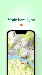
A wide selection of maps and overlays, available even offline
Iphigénie provides access to a broad range of maps: IGN France, IGN Spain, IGN Belgium, swisstopo, Italian Fraternali maps, Geo4Map, Lupo (Apennines), Geoportale Nazionale, OpenStreetMap, OpenTopoMap, BKG (Germany), Kartverket (Norway), Institut Cartogràfic de Catalunya, OpenSnowMap, Utagawa VTT, CyclOSM, as well as aeronautical ICAO charts, geological and mining maps, and glider flight charts.
You can also explore historical maps (19th-century État-Major maps, Paris 1906, Guyana 1780, satellite imagery from 1950–2005) to enrich your navigation references.
The app includes numerous overlays: land registry (cadastre), Petzl tracks, slope angle shading, hiking trails, satellite views and aerial imagery, detailed administrative boundaries (regions, departments, cantons, municipalities, EPCIs), National Forestry Office drone restriction zones, and more.
Most maps and overlays can be downloaded directly to your phone, allowing you to locate yourself and navigate even without an internet connection — including in remote areas. You can also print selected map sections.
The most precise HD satellite map of the Mont Blanc massif on the market
Explore the Mont Blanc massif with unmatched precision thanks to Iphigénie’s winter HD satellite map.
Specifically designed for ski touring, it provides a clear and detailed view of snow-covered terrain: glaciers, couloirs, relief features, and forested areas are visible with exceptional accuracy to help you better prepare your routes.
Downloadable for offline use. Additional mountain ranges will be available soon.
Tools to navigate with confidence
Create, import, and edit your routes. Geolocate yourself on the map background of your choice and add custom waypoints, such as trailheads, mushroom spots, or mountain huts.
Search easily for a place by name or GPS coordinates (feature available in France only).
Accurate activity tracking
Track your distances, elevation gain, speed, and estimated time of arrival. Use the 3D view and slope angle display to better understand the terrain.
Your position is tracked in real time via GPS, and your route is automatically recorded. The tracking feature also helps reassure your loved ones.
Organize and share your routes
Store your routes and waypoints in a secure space. Organize your data into groups and export or share your files in GPX format.
For added comfort, plan your outings from the web version on a larger screen.
With the “Italian Alps Maps” subscription, access high-quality mapping coverage for Italy.
Share your location with beacons
Beacons allow you to share your real-time position with loved ones — and see where they are too.
Especially useful during outdoor activities, they provide extra safety and peace of mind.
Committed to the planet
Iphigénie donates 1% of its annual revenue to 1% for the Planet to help protect the environment.
Made in France.
A French application
Our app has been developed in France since its creation by outdoor and mapping enthusiasts.
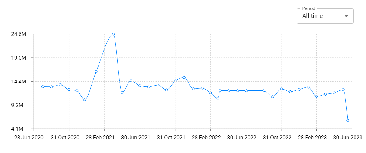
Iphigénie | Offline Maps Revenue and Downloads
Measure Iphigénie | Offline Maps performance and get insights with AppstoreSpy data you won’t find anywhere else using our Analytics, Revenue Stats ans Trends.
Iphigénie | Offline Maps Global Top Charts: Interactive Map of Country and Category Rankings
Iphigénie | Offline Maps Revenue and Installs Distribution by Countries
Iphigénie | Offline Maps Changelog

App contains SDKs
Iphigénie | Offline Maps Ad сreatives

Iphigénie | Offline Maps Paywalls
