onX Offroad: Trail Maps & GPS
Off-Roading Navigation App With Trails, Public Lands, & Private Property Info
3.6 ★
Off-Roading Navigation App With Trails, Public Lands, & Private Property Info
Best onX Offroad: Trail Maps & GPS Images and Marketing Description


Navigate off-road and find the trails you’re looking for with onX Offroad. GPS mapping, 3D trail maps, and Location Sharing — discover what’s open nearby or explore something new with ease.
Filter trails by accessibility for 4x4, SxS, dirt bikes, moto, ATV/Quads, Overland, and snowmobiles. Identify free camping areas in National Forests using USFS verified data with our Motorized Dispersed Camping Layer. View property lines, private landowner information, and acreage right in the app.
Uncover new forest trails or use onX Offroad to access thousands of miles of snowmobile trail information across the country. Access a GPS navigation tool that lets you stay connected with Cell Coverage Layers. Ride at your own pace and see your whole crew move in real time with Location Sharing, onX Offroad’s newest feature.
Get GPS directions from the tarmac to the trails with turn-by-turn navigation and sync onX Offroad with Android Auto. Save Offline Maps to your phone or tablet. Find trailheads, trailer parking, non-ethanol fuel stations, campgrounds, and more.
Adventure starts where the pavement ends. Go where other maps can’t with onX Offroad.
onX Offroad Features:
▶ OHV Trails & Map Layers
• Find trails for your activity – SxS, 4x4, ATV, dirt bikes, snowmobiles, and more
• Toggle map layers for info on weather, land boundaries, and cell service
• Navigate off-road and identify cell coverage areas for AT&T, Verizon, and T-Mobile
• Monitor wildfires and drifting smoke with data from the NIFC and NOAA
▶ Off-Road Navigation & Route Builder
• View trail conditions, including difficulty ratings, and open/close dates
• Save Offline Maps without losing interactive land and trail data
• Get off-road turn-by-turn directions with voice commands. Sync with Android Auto
• Map routes that automatically snap to roads and trails
▶ Trip Tracker & Recreation Points
• See your group move in real time with live, session-based Location Sharing
• Find camping spots that are legal and free along motorized trails in National Forests
• Track distance, location, speed or elevation. Save and share trips with friends
• Add Waypoints to mark campsites, fuel stations, fishing access, rock crawls, and more
▶ Nationwide Property Lines (Limited by Membership)
• GPS navigation and versatile map imagery – 3d, topo, satellite or hybrid
• Access public and private land ownership information across the nation
• Identify National Forest, BLM, National Park land and more
Download onX Offroad and experience a trusted planning, mapping, and navigation app that always gets you home safely.
▶ Free Trial
Start a trial for free when you install the app. Experience the difference of a premier off-roading tool and plan your next adventure.
▶ Offroad Memberships:
Enjoy our premium features with an onX Offroad membership. Roam in parts unknown with property maps, cell coverage info, and industry brand discounts.
• 650K+ miles of motorized roads and off-road trails
• Trails for 4x4, Side-by-Side, dirtbikes, dual sport, ATV, Quads, Overlanding, and snowmobiling
• 852M acres of public land across the U.S.
• 24K topographic maps and 3D maps for the entire U.S.
• Save Offline Maps for navigation without cell service
▶ Government Information & Data Sources
onXmaps, Inc. does not represent any government or political entity, though you may find various links to public information within our services. For more information on any government information found within the services, click on the associated .gov link.
• https://data.fs.usda.gov/geodata/
• https://gbp-blm-egis.hub.arcgis.com/
• https://www.arcgis.com/home/group.html?id=00f2977287f74c79aad558708e3b6649#overview
▶ Terms of Use: https://www.onxmaps.com/tou
▶ Privacy Policy: https://www.onxmaps.com/privacy-policy
▶ Feedback: If you have any trouble or have an idea of what you’d like to see in the app next, please contact us at support@onxmaps.com. We’d love to hear from you.
onX Offroad: Trail Maps & GPS Revenue and Downloads
Measure onX Offroad: Trail Maps & GPS performance and get insights with AppstoreSpy data you won’t find anywhere else using our Analytics, Revenue Stats ans Trends.
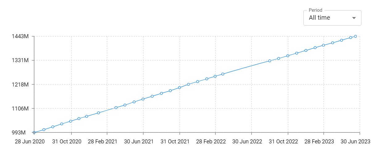
onX Offroad: Trail Maps & GPS Total Installs and Downloads charts
Explore onX Offroad: Trail Maps & GPS Total Installs to gain a deeper understanding of the app
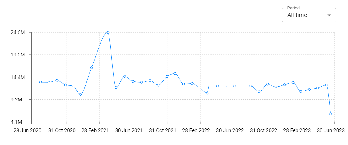
onX Offroad: Trail Maps & GPS Daily Installs and Downloads charts
Explore onX Offroad: Trail Maps & GPS Daily Installs to gain a deeper understanding of the app
onX Offroad: Trail Maps & GPS Global Top Charts: Interactive Map of Country and Category Rankings
onX Offroad: Trail Maps & GPS Revenue and Installs Distribution by Countries
onX Offroad: Trail Maps & GPS Changelog

App contains SDKs
onX Offroad: Trail Maps & GPS Ad сreatives