Live Earth: GPS Map Tracker
Explore a stunning 3D world map—track GPS locations and view Earth in real time
★
Explore a stunning 3D world map—track GPS locations and view Earth in real time
Best Live Earth: GPS Map Tracker Images and Marketing Description


🌍 Live Earth: GPS Map Tracker – Explore the World in 3D
Experience the planet like never before with Live Earth: GPS Map Tracker, a powerful 3D world map app that brings real-time satellite imagery, street views, and accurate GPS navigation together in one immersive experience.
Whether you want to explore distant cities, navigate daily routes, or view the Earth from above, this app lets you discover the world with stunning clarity and precision.
🌐 Explore the World in Real-Time
Travel across continents from your screen with high-resolution satellite imagery and realistic 3D terrain views. From towering mountains to bustling cities and quiet rural roads, every location is rendered with depth, accuracy, and detail.
With active satellite data, you can explore the Earth anytime, anywhere—making the app useful worldwide.
Key Features & Highlights
🌍 3D City & Terrain Views with real-time rendering
🛰️ Live Satellite Imagery for a global Earth view
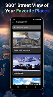
📍 Street View & 360° Panoramas to explore locations virtually
🧭 Accurate GPS Navigation with turn-by-turn guidance
📌 Real-Time Location Tracking with pinpoint precision
🔍 Quick Search for cities, streets, and landmarks
🚶 Walk-through Simulation for realistic exploration
🧼 Clean & Simple User Interface
🌎 Works Worldwide using live satellite data
🧭 Smarter Navigation Made Easy
Never miss a turn again. With advanced GPS tracking, the app helps you find optimal routes, nearby locations, and destinations effortlessly. Whether you’re commuting, traveling, or exploring a new city, navigation becomes smooth and reliable.
Street View allows you to preview roads and surroundings in advance, giving you confidence before you step out.
🌏 See the Earth from Every Angle
Enjoy a breathtaking, bird’s-eye view of the planet. Zoom in on famous landmarks, rivers, mountains, and cities, or zoom out to admire the Earth as a whole. The combination of 3D Earth views, satellite maps, and street-level imagery delivers a truly immersive experience.
🗺️ Your Perfect Travel Companion
Planning a trip? Easily locate airports, restaurants, gas stations, hotels, ATMs, and more. See locations before visiting and explore surroundings virtually to make smarter travel decisions.
Whether you’re a traveler, explorer, or daily commuter, Live Earth: GPS Map Tracker enhances every journey.
🚀 Start Exploring Today
Discover the planet with Live Earth: GPS Map Tracker—where real-time satellite data, 3D maps, and GPS navigation come together to help you explore, navigate, and experience the Earth like never before.
Live Earth: GPS Map Tracker Revenue and Downloads
Measure Live Earth: GPS Map Tracker performance and get insights with AppstoreSpy data you won’t find anywhere else using our Analytics, Revenue Stats ans Trends.
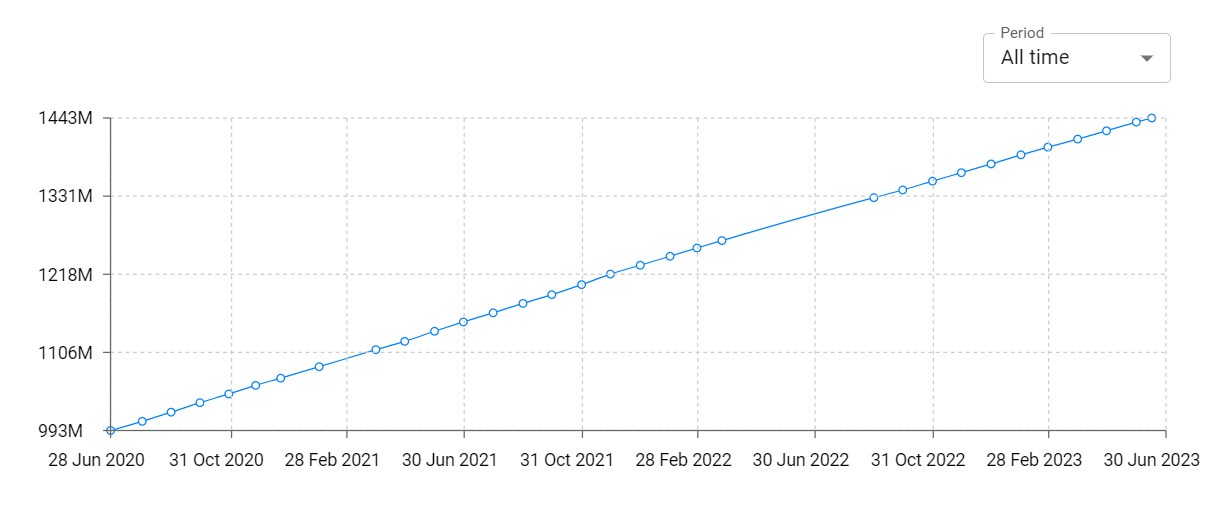
Live Earth: GPS Map Tracker Total Installs and Downloads charts
Explore Live Earth: GPS Map Tracker Total Installs to gain a deeper understanding of the app
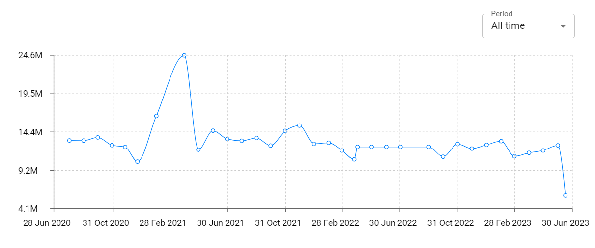
Live Earth: GPS Map Tracker Daily Installs and Downloads charts
Explore Live Earth: GPS Map Tracker Daily Installs to gain a deeper understanding of the app
Live Earth: GPS Map Tracker Global Top Charts: Interactive Map of Country and Category Rankings
Live Earth: GPS Map Tracker Revenue and Installs Distribution by Countries
Live Earth: GPS Map Tracker Changelog

App contains SDKs
Live Earth: GPS Map Tracker Ad сreatives