World 3D: Earth Map Satellite
Explore Earth in 3D with live cameras, street view, GPS tools & air quality
★
Explore Earth in 3D with live cameras, street view, GPS tools & air quality
Best World 3D: Earth Map Satellite Images and Marketing Description


World 3D: Earth Map Satellite brings the world to your fingertips with live global cameras, realistic 3D Earth views, street exploration, traffic maps, GPS tools, and real-time environmental data. Discover places, track conditions, and explore the planet in an easy and interactive way.
🌐 Key Features
📡 Live Cameras Worldwide
Watch real-time camera feeds from locations across the globe.
Experience cities, nature spots, beaches, landmarks, and more — all on your device.
🌍 3D Earth Map
Explore a fully interactive 3D model of the Earth.
Zoom, rotate, and navigate through continents, oceans, and popular destinations.
🚶 Street View
Walk through streets virtually and explore famous places with detailed panoramic images.
🌀 360° Panorama
View immersive 360° photos for a realistic on-the-ground experience at various locations.
🌫 Air Quality (AQI)
Check the air quality index in real time to plan outdoor activities safely.
🗺 Traffic Map
Stay updated with traffic conditions and choose the best route before you travel.
⭐ Famous Places
Discover iconic spots, natural wonders, and tourist attractions around the world.
🧭 Compass
A simple and accurate compass to help you navigate anytime, anywhere.
📱 Phone Locator
Enter any phone number to find its precise location using the Phone Number Locator.
🌎 World Clock
Check local time zones worldwide for travel, business, or communication.
📸 GPS Camera
Capture photos with automatic location stamps including coordinates, date, and time.
👍 Why You’ll Love World 3D: Earth Map Satellite
- Easy-to-use interface and modern design
- Real-time global data and tools in one app
- Great for travel, outdoor activities, learning, or exploration
- Helps you stay informed about traffic, weather, and environmental conditions
🚀 Start Exploring Today
Download World 3D: Earth Map Satellite and enjoy a smarter way to discover the planet!
World 3D: Earth Map Satellite Revenue and Downloads
Measure World 3D: Earth Map Satellite performance and get insights with AppstoreSpy data you won’t find anywhere else using our Analytics, Revenue Stats ans Trends.
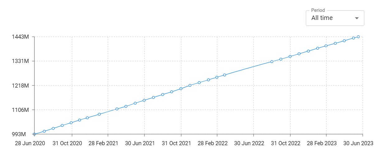
World 3D: Earth Map Satellite Total Installs and Downloads charts
Explore World 3D: Earth Map Satellite Total Installs to gain a deeper understanding of the app
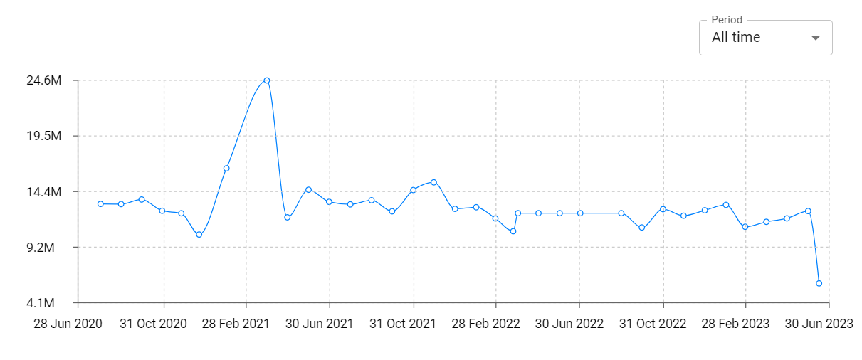
World 3D: Earth Map Satellite Daily Installs and Downloads charts
Explore World 3D: Earth Map Satellite Daily Installs to gain a deeper understanding of the app
World 3D: Earth Map Satellite Global Top Charts: Interactive Map of Country and Category Rankings
World 3D: Earth Map Satellite Revenue and Installs Distribution by Countries
World 3D: Earth Map Satellite Changelog