
GPS map for mountain & biking trails. Get trail status & community reports
Best Trailforks Images and Marketing Description


Explore the largest database of the best trails, right in your pocket with Trailforks. Enjoy the top cycling tracker and trail navigation app, with tools that help you make the most of your winter skiing, snowboarding, and winter biking adventures. Never get lost with Trailforks’ detailed directions on the way to the trailhead.
Get the premier mountain cycle tracker providing the top backroads trails nearby, cycling maps, distance tracker, GPS, condition reports, trailhead navigation, and route tracker – all in Trailforks.
With access to 780,000+ of the best routes for your next biking adventure, cycling, riding, training, snowboarding, skiing, winter biking, & everything in between – Trailforks is the top solution for navigating the outdoors. Discover detailed trail condition reports and status from trail associations and locals. Track adventures with the most powerful activity tracker. Download the leading navigation app and get ready for your next trail, ride, or hike.
LEADING CYCLING APP
-Ultimate biking app with the world’s largest trail database for any activity – snowboarding, ebiking, dirt biking, skiing, winter biking, and more
- GPX compatibility. Sync your Garmin or Wahoo device
- Create and share local routes
- Plan adventures with the best topo and terrain maps
- Save bike trails to your Wishlist
- Activity tracker lets you track your mileage
- Find directions to nearby bike shops
- Orient maps in the direction you’re facing
- Track down the trailhead with driving directions
JOIN THE BEST COMMUNITY
- Find inspiration and community in the Trailforks activity feed
- Connect devices and apps to share your stats and achievements with photos and comments
- Follow friends to discover new routes from the best maps
- Explore bike and gear reviews, destination guides, race coverage, and more from the experts at Outside, Pinkbike, and Velo.
- Access 1 million photos, videos, and 3M trail reports
ULTIMATE MULTI-ACTIVITY SUPPORT
- Trailforks is also the ultimate app for day hiking, backpacking, winter biking, skiing, or snowboarding
- Route builder tool for hiking, trail running, skiing, and more.
- Free maps with thousands of related points of interest (POIs).
- Best-in-class topo, satellite, activity, and jumps heat maps to help you stay safe on your next outdoor adventure
ROUTE TRACKER, TRAIL EVENTS, WEATHER REPORTS, & ALERTS
- Monitor and track trail conditions & closures
- View events nearby or by region
- Share your map location with friends & emergency services
- Check weather & submit trail reports
- Earn activity and contribution badges while biking, snowboarding, skiing, winter biking, and more
- Sync and view saved 'Route Plans' from web to app
THE BEST TOPOGRAPHIC MAPS FOR PLANNING AND NAVIGATION
- See every climb and descent with in-app route elevation profiles and real-time ride tracking
- Toggle Pro map layers like slope angle, light pollution, USFS, land ownership, & more!
- Create routes to your preferred trailhead
- Explore detailed U.S. land ownership maps, including BLM and other public lands
- View mapped boundaries for private property and closed areas
UPGRADE YOUR RIDE WITH TRAILFORKS PRO WITH OUTSIDE+
- Unlock nationwide map access, including Garmin base maps
- Priority sync with your Garmin or Strava device
- Enjoy unlimited waypoints & wishlists
- Access desktop-to-app cycling tools like printmap & downloadable GPX & KML files
- Premium subscription to access the Gaia GPS backcountry adventure app
- Expert-led online courses on Outside Learn
- Premium access to award-winning films, shows, and live TV on OutsideYV- Unlimited digital access to Outside Network's 15 iconic brands, including Outside Online, Velo, and Pinkbike
The best, detailed trail maps for renowned mountain biking destinations such as Whistler, Squamish, North Shore, Kamloops, Nelson, Moab, Downieville, Colorado Springs, Bellingham, Bentonville, Finale Ligure, Pisgah, Marin, Bend Oregon, Wellington, & Rotorua New Zealand.
Trailforks Revenue and Downloads
Measure Trailforks performance and get insights with AppstoreSpy data you won’t find anywhere else using our Analytics, Revenue Stats ans Trends.
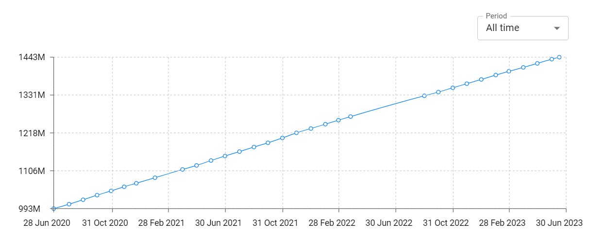
Trailforks Total Installs and Downloads charts
Explore Trailforks Total Installs to gain a deeper understanding of the app
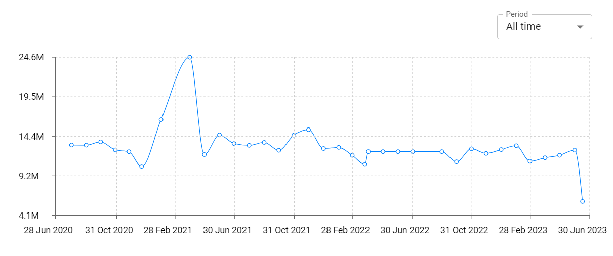
Trailforks Daily Installs and Downloads charts
Explore Trailforks Daily Installs to gain a deeper understanding of the app
Trailforks Global Top Charts: Interactive Map of Country and Category Rankings
Trailforks Revenue and Installs Distribution by Countries
Trailforks Changelog

App contains SDKs
Trailforks Ad сreatives

Trailforks Paywalls
