Live Earth Map & GPS Tracker
GPS Map Camera & Live Earth Tracker, Real-Time Satellite & Geotag Photos
4.2 ★
GPS Map Camera & Live Earth Tracker, Real-Time Satellite & Geotag Photos
Best Live Earth Map & GPS Tracker Images and Marketing Description


Discover the planet in real-time and stay connected with your loved ones!
Live Earth Camera & GPS Tracker is your ultimate tool for global exploration, smart navigation, and real-time connection. Explore famous landmarks, view maps live street maps, monitor speed limits, travel through time on the GPS map, and stay updated on where your friends are right now—all in one powerful live location app.
🆕 NEW FEATURE: Sky Map
Discover the beauty of the universe right from your device. The Sky Map feature lets you explore the night sky in real time and identify stars, planets, and constellations based on your GPS location.
- Live Sky View: See stars, planets, and constellations in real time.
- Location-Based Mapping: Sky map adjusts automatically to your GPS camera location.
- Constellation Guide: Identify famous star patterns and celestial objects.
- Perfect for Stargazing: Ideal for learning, curiosity, and night sky exploration.
- Easy to Use: Simple and interactive sky navigation for all ages.
Key Features of Live Earth Map & GPS Tracker:
👥 Friend Tracker: Locate friends and family in real-time using GPS sharing share codes with our live GPS tracker.
🌍 Live Global Camera Access: Watch live earth camera feeds from locations worldwide with our geo camera app.
🚗 Speed Map Limit: Real-time road speed limit display for safer driving with maps camera overlay.
🌌 Sky Map: Explore the maps live sky to view stars, planets, and constellations based on your live GPS location.
📍 GPS Geotagged Camera: Capture GPS photo stamp images with accurate location data using our geo tagging camera and geotagging photos camera app.
🏘️ Map-Integrated Gallery: View GPS camera photo images directly on an interactive GPS map camera with photomap support.
🖊️ Edit with Geotags: Customize geotag photos pro while keeping GPS data intact. Use add geotag, geo stamp, and GPS tag photo features effortlessly.
See the World in 3D and Real-Time
Explore Earth in stunning 3D GPS map view, enjoy street-level navigation, and view live earth view real time satellite maps. Use GPS 3D map live to go from busy cities to remote landscapes for a realistic and immersive experience with our map satellite and earth map satellite technology.
Accurate Navigation and Location Tracking
Never miss a turn or lose track of loved ones. With our GPS tracking app, precise GPS map camera time stamp, live GPS satellite map, and real-time friend tracking via live GPS tracker, you always stay informed and in control. Our geofencing app adds an extra layer of location awareness for peace of mind.
Your Essential Travel and Social Companion
Preview destinations with organic maps, check speed limits, explore historical locations with timestamp camera and timestamp photo features, and coordinate meetups with ease. Whether traveling, driving, or exploring from home, our GPS map camera location keeps you connected. Use GPS photo location, map location camera, and gps camera map and geotag photos to document every journey beautifully.
Experience the Planet Like Never Before
By combining live earth maps, speed limit tracking, my GPS location sharing, geo GPS camera, and map live earth camera feeds, Live Earth Map & GPS Tracker delivers a complete navigation and exploration experience. Our geo map camera, GPS stamp camera, geo stamp camera, and cam GPS tools make this the most complete map apps solution available.
Start your journey now with Live Earth 3D & Satellite Map - your window to the world, through space and time!
Live Earth Map & GPS Tracker Revenue and Downloads
Measure Live Earth Map & GPS Tracker performance and get insights with AppstoreSpy data you won’t find anywhere else using our Analytics, Revenue Stats ans Trends.
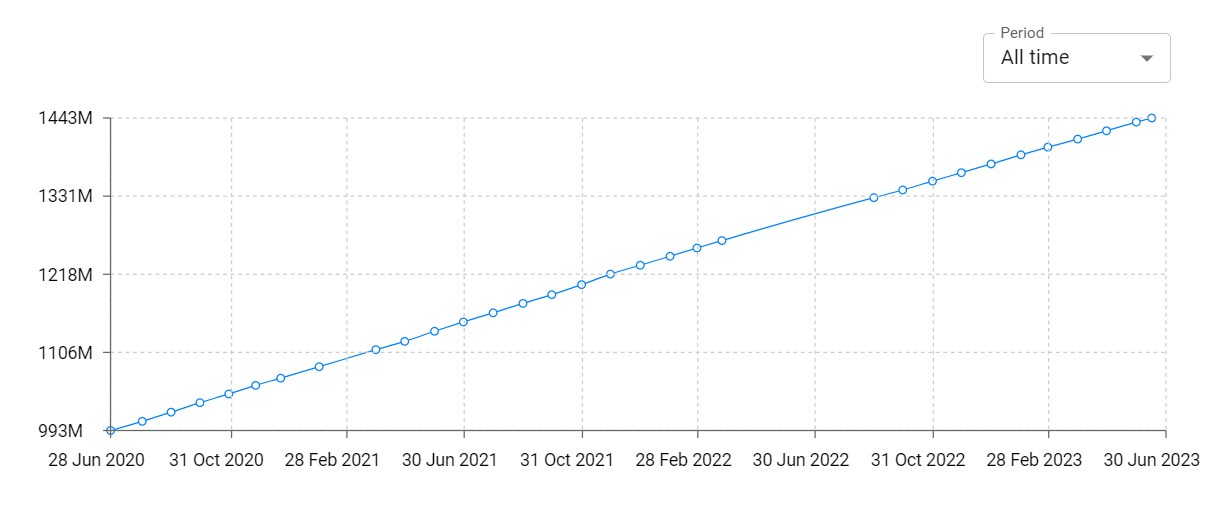
Live Earth Map & GPS Tracker Total Installs and Downloads charts
Explore Live Earth Map & GPS Tracker Total Installs to gain a deeper understanding of the app
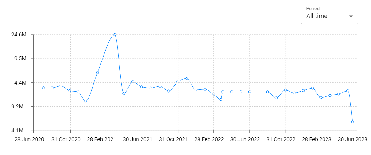
Live Earth Map & GPS Tracker Daily Installs and Downloads charts
Explore Live Earth Map & GPS Tracker Daily Installs to gain a deeper understanding of the app
Live Earth Map & GPS Tracker Global Top Charts: Interactive Map of Country and Category Rankings
Live Earth Map & GPS Tracker Revenue and Installs Distribution by Countries
Live Earth Map & GPS Tracker Changelog

App contains SDKs
Live Earth Map & GPS Tracker Ad сreatives