Map Camera Pro : Geotag Photos
Capture and Preserve Your Travel Memories with Map Camera Pro : Geotag Photos
★
Capture and Preserve Your Travel Memories with Map Camera Pro : Geotag Photos
Best Map Camera Pro : Geotag Photos Images and Marketing Description


Take precise pictures with our Map Camera Pro, which automatically adds timestamps, map stamps, and real-time location information to your images. With the map camera app, it's easy to add latitude, longitude, and weather details to every photo.
Use Map Camera: Geotag Photos & Add GPS Location to track your current position and organize your photos efficiently. Capture and share your best travel moments by sending geotagged images to your loved ones.
How to Use Map Camera:
1. Install the Map Camera: Geotag Photos & Add GPS Location app on your smartphone.
2. Use the camera, select from a variety of advanced templates, and set the stamp formats and settings to your liking.
3. Start taking photos with automatically added GPS location stamps.
Key Features:
Wind: Measure wind speed
Humidity: Display current humidity
Pressure: Measure atmospheric pressure
Address: Add manual or automatic address details
Weather: Display the temperature in °C \°F.
Custom GPS Camera: Includes aspect ratios, front & flash, focus control, timer, dashcam level, and filters
Why You Need the GPS Camera App:
Add satellite map stamps to your photos
Take precise images with date/time stamps and geotags.
Photos with location tags are easy to organize and find. You can also securely track locations with GPS geotag images
Include longitude, latitude, address, date, time, and weather on each photo
Whether you are using it for professional documentation or to organize your gallery, this Map Camera is your all-in-one tool for location-tagged photography.
Download the Map Camera Photos Geotag & Add GPS Location app today to explore all these features and more!
Map Camera Pro : Geotag Photos Revenue and Downloads
Measure Map Camera Pro : Geotag Photos performance and get insights with AppstoreSpy data you won’t find anywhere else using our Analytics, Revenue Stats ans Trends.
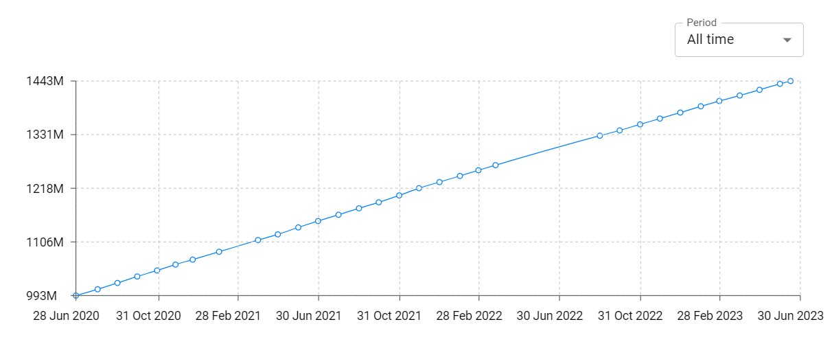
Map Camera Pro : Geotag Photos Total Installs and Downloads charts
Explore Map Camera Pro : Geotag Photos Total Installs to gain a deeper understanding of the app
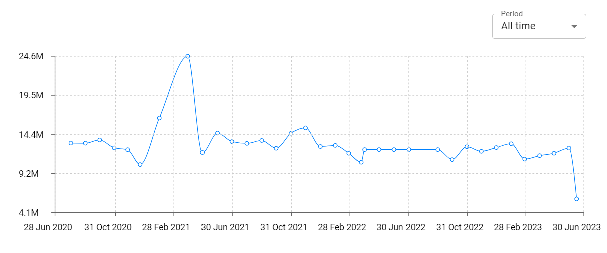
Map Camera Pro : Geotag Photos Daily Installs and Downloads charts
Explore Map Camera Pro : Geotag Photos Daily Installs to gain a deeper understanding of the app
Map Camera Pro : Geotag Photos Global Top Charts: Interactive Map of Country and Category Rankings
Map Camera Pro : Geotag Photos Revenue and Installs Distribution by Countries
Map Camera Pro : Geotag Photos Changelog